Categorie
LandAware network News from members WG02 Communication-Networking

Webinars on Landslide Monitoring for Early Warning Systems

NEWS received from
Jose Antonio Gili Ripoll (UPC, Spain)

On behalf of the PyrMove and GeoRisk projects, we are happy to announce four one-hour webinars on “Landslide Monitoring for Early Warning Systems” (2nd Edition), to be held this April, every Wednesday after lunchtime.

The webinar series goal is to disseminate new techniques and concepts that might help in landslide monitoring and modelling. These new solutions may be the base of some Early Warning Systems for controlling and managing the risk, in order to reduce damage or losses.

The webinars are addressed to professionals working in the risk management field, but also to the administration and public authorities responsible of the landslide and rockfall prone areas. Academics and students are also welcomed!

Webinars agenda

Wednesday, 6th of April, 2022. 15:00-16:00 (CEST)
Mixed Reality tools for visualization of complex spatial data in geomechanics – by Joan Roca (BGC Engineering)

Wednesday, 20th of April, 2022. 14:00-15:00 (CEST)    
Distributed fiber optic sensing for geotechnical monitoring – by Werner Lienhart (T. U. Graz)

Wednesday, 27thof April, 2022. 14:00-15:00 (CEST)
Filling the gap between monitoring and modelling in geotechnical engineering – by Cristian de Santos (SAALG Geomechanics)

Wednesday, 4th of May, 2022. 14:00-15:00 (CEST)
Slope stability monitoring using Remote IoT Technology – by Àngela Lluch & Víctor Salines (WorldSensing)

————-

Practical directions to follow the webinars

The technical sessions will be held in English. The attendance is free. The webinars will be held online through a Google Meet session

For the first webinar (Wednesday, 6 April · 15:00) the link will be: https://meet.google.com/sif-ftdu-oxd  (Meet code: sif-ftdu-oxd)

Next sessions will use a different MEET code. To be invited to one or several days, a simple pre-webinar registration is required: you must send an email to
EWS.webinars.April2021@gmail.com (the “2021” in the address is not a mistake, this gmail was configured for the 1st edition!) indicating your intention to attend to one or several webinars. You will receive the webinar link the day before each session.

In this link you may find a PDF with the factual information about the four webinars, a short description about the ‘PyrMove’ and the ‘GeoRisk’ projects and some useful links.

If you want, you can watch the four last-year webinars (April 2021) at the Youtube Webinar channel

For additional information, do not hesitate to contact the webinars ‘curators’: j.gili@upc.edu Technical University Catalonia (UPC)  &
marc.janeras@icgc.cat Institut Cartogràfic Geològic Catalunya (ICGC, Barcelona, Spain)

Categorie
LandAware network

Presentation of the network at WLF5

Presentation of the LandAware network at WLF5, the 5th World Landslide Forum “Implementing and Monitoring the Sendai Landslide Partnerships 2015-2025” (2-6 November 2021, Kyoto, Japan)

Theme 3: Monitoring and Early Warning

Companion paper, published on Landslides https://link.springer.com/article/10.1007/s10346-020-01548-7

Categorie
LandAware network News from members

“News from members”: an outlet for sharing news related to LEWS

“News from members” is a new category of the blog aiming at creating a virtual space on this website for LandAware members to share news related to LEWS. The blog posts published in this category will also be sent via email to LandAware members and to the subscribers of our newsletter.

At any time, if you want to share YOUR news in this category, simply

  • send to us an email at info@landaware.org with the text of your message and a proposed title of the blog post
  • wait for us to review your message
  • read your message online (and further share it in social media) after it gets published

We are looking forward to receiving and sharing your news.

Categorie
LandAware network WG02 Communication-Networking WG04 eLearning

Meet the LandAware experts

Some of the interviews broadcast in short versions during the
LandAware MayDay round-the-clock conference.
Here are the extended versions of all interviews.

Mateja Jemec Auflič
(Geological Survey of Slovenia)
The Slovenian Landslide Prediction System
Interview to Mateja Jemec Auflič, by Stefano Luigi Gariano

————————-

Paolo Mazzanti & Saverio Romeo
(NHAZCA)
Interview to Paolo Mazzanti and Saverio Romeo, by Stefano Luigi Gariano

————————-

Nicola Casagli
President of the International Consortium on Landslides
Interview to Nicola Casagli, by Stefano Luigi Gariano

————————-

Davide Bertolo (Aosta Valley Region, Italy)
Daniele Giordan (CNR IRPI)
Communication strategy at the Mont de La Saxe monitoring system
Interview to Davide Bertolo and Daniele Giordan, by Stefano Luigi Gariano

————————-

Lene Kristensen & Gustav Pless
(Norwegian water resources and energy directorate)
Local LEWS operating for the Aknes and Mannen landslides in Norway
Interview to Lene Kristensen and Gustav Pless, by Michele Calvello

————————-

Davide Tiranti (ARPA Piemonte, Italy)
The territorial LEWS in Piemonte region, northern Italy.
Interview to Davide Tiranti, by Michele Calvello

————————-

Tulius Dias Nery
(Brazilian National Center for Alert Monitoring and Natural Disasters)
Interview to Tulius Dias Nery, by Isabela Horta

————————-

Alessandro Mondini (CNR IRPI)
SAR for landslide failure detection and mapping
Presentation by Alessandro Mondini

————————-

Mauro Rossi (CNR IRPI) and WG1 members
A glossary for LEWS community
Presentation by Mauro Rossi (CNR IRPI)

————————-

Categorie
LandAware network WG03 Communication with stakeholders

MayDay session on Communication and stakeholder engagement for LEWS

Blog post by Mirianna Budimir

We want to hear from you!

Challenges still remain in bridging the gap between providing scientific warning information and translating that into useful information for stakeholders. Best-practice guidance for early warning systems recommends engaging with stakeholders to co-produce useful forecast and warning information for decision makers. However, this is still a big ask and barriers, challenges, and gaps still remain in this process – including for landslide early warning systems. To address these challenges, LandAware have established a Working Group focusing specifically on this topic.

As part of the MayDay conference, Dr. Mirianna Budimir, Senior DRR Advisor from Practical Action, an international development organisation with global expertise in early warning systems, will share existing lessons and best practice from the wider early warning system field that can be applied specifically to landslide early warning systems. Using examples from operational landslide early warning systems, she will share key learning and practical recommendations about communicating warnings and engaging with stakeholders effectively.

As part of the session, we will invite participants to share their experiences of working with stakeholders and developing communication strategies for landslide early warning systems. We want to hear and share your experiences, challenges, strategies, successes, and lessons, in order to learn from each other within LandAware. Your reflections and questions will also inform the development of SHEAR programme guidance materials aimed at supporting better communication and stakeholder engagement for LEWS.

If you are interested in participating and contributing to the conversation, don’t forget to add it to your calendar:

20th May, 10:00-11:00 CEST

Contact us to feature in an upcoming publication

Are you involved in issuing landslide forecasts or warnings as part of an operational, live system? If so, please contact Mirianna to share your experiences outside of (or in addition to) the MayDay session. Your input will contribute to and could feature in an upcoming SHEAR programme publication which will provide examples and guidance on developing forecast information for institutional decision makers.

Categorie
LandAware network

The first LandAware round-the-clock conference will be a “MayDay”

Join us for the LandAware MayDay round-the-clock Conference!

When: from 19 May 2021 14:00 CET to 20 May 2021 14:00 CET

Where: online (free registration required)

What: see the preliminary program

And if have one or more photos regarding landslides or landslide early warning to share… participate in the MayDay 2021 photo contest

Updated info at:
https://www.landaware.org/mayday-2021/

Categorie
LandAware network

Recording of LandAware kick-off 2020

The recording of the LandAware kick-off meeting, held on 14 December 2020, is on YouTube for you to watch on demand.

Enjoy it!

Categorie
LandAware network

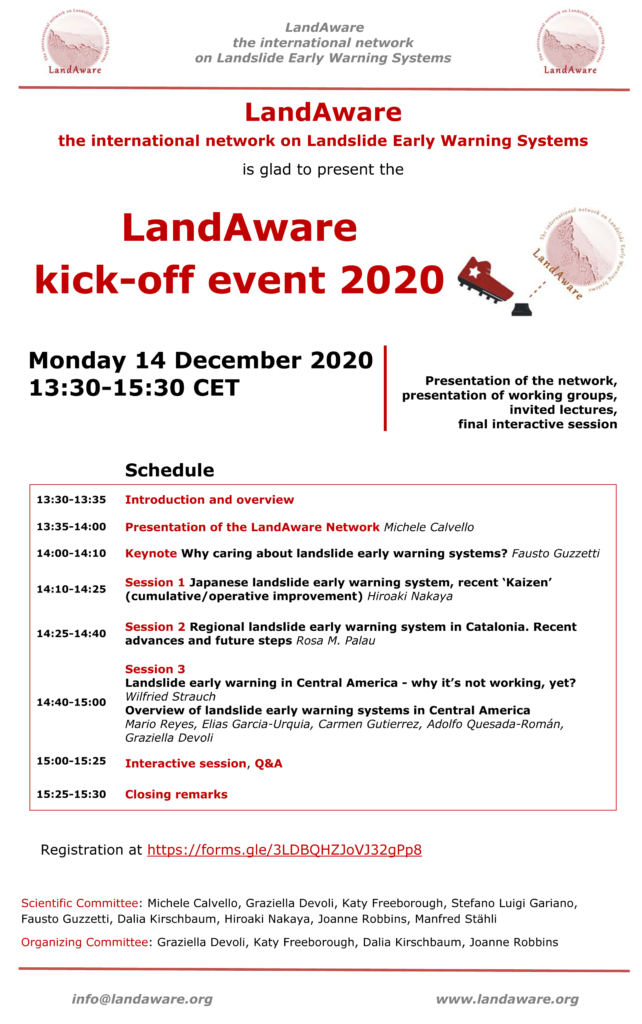
LandAware kick-off 2020

The kick-off event of the network will take place online on Zoom on Monday 14 December 2020, 13:30-15:30 CET.

REGISTER by filling the following Google form: https://forms.gle/chVsgEiUr69GBDWS7
(the link to join the Zoom meeting will be sent by email to registered participants 1-day before the event)

The 2-hour event will include a presentation of the network and of its working groups, as well as invited lectures and a final interactive session (see detailed program below).

Schedule of the event

Note: being aware that the time of the event will not allow the easy participation of potentially interested people from all time-zones, the event will be recorded and later posted online for watching on demand.

Categorie
LandAware network

International Day for Disaster Risk Reduction “LandAware is committed!”

The International Day for Disaster Risk Reduction celebrates, since many years, how people and communities around the world are reducing their exposure to disasters and raising awareness about the importance of reining in the risks that they face.

LandAware, the multi-disciplinary international network of experts in Landslide Early Warning Systems, sees worldwide cooperation and experience sharing among professionals and researchers as a primary driver for addressing and promoting (landslide) Disaster Risk Reduction.

We are young, we are just born, but we are already committed!

Categorie
LandAware network

LandAware in the journal “Landslides”

A News/Kyoto Commitment article has been published today (online first) on the scientific journal “Landslides” to present the LandAware network to the many readers of the journal.

Calvello M, Devoli G, Freeborough K, Gariano SL; Guzzetti F, Kirschbaum D, Nakaya H, Robbins J, Stähli M (2020). LandAware: a new international network on Landslide Early Warning Systems. Landslides, online first.
http://doi.org/10.1007/s10346-020-01548-7

Extracts from the article

Many recent international initiatives have been highlighting the importance of EWSs for disaster risk reduction purposes. [..] In response to these global initiatives, natural hazard experts working with EWSs around the world have recently founded programs and networks to promote international collaboration among members engaged in both surveillance of natural hazards and issuance of warnings to key stakeholders (authorities and public). Among them we can mention multi-hazard initiatives, such as the multi-stakeholder International Network for Multi-Hazard Early Warning Systems promoted by the World Meteorological Organization, as well as initiatives focusing on single natural hazards, such as the Intergovernmental Oceanographic Commission Tsunami Programme, the World Organization of Volcanic Observatories, the Global Seismographic Network of the IRIS consortium in the USA, and the European Avalanche Warning Services. Filling a gap in this global scenario, and in response to the abovementioned requests from the landslide risk scientific community, in July 2020 a multi-disciplinary international network of experts in LEWS was founded. The network is named “LandAware – the international network on Landslide Early Warning Systems”.

[..] upcoming activities of LandAware will always be, given the stated purposes of the network, in line with Kyoto Landslide Commitment 2020 priority action no. 1, which aims at promoting “the development of people-centered early warning technology for landslides with increased precision and reliable prediction both in time and location, especially in a changing climate context.”