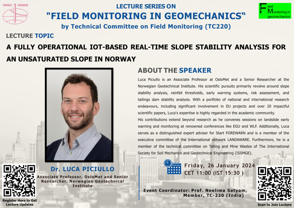
The next International Society for Soil Mechanics and Geotechnical Engineering (ISSMGE) – TC220 Field Monitoring in Geomechanics series of international lectures will take place on Friday 26th of January 2024 at 11:00 CET. It will be given by Dr. Luca Piciullo, with a lecture on “A fully operational IoT-based real-time slope stability analysis for an unsaturated slope in Norway”. This is the fifth in this very successful series of lectures.
The lecture will be introduced by Dr. Neelima Satyam.
To join the lecture, please use the following link: https://lnkd.in/g8Cn_W2D or scan the QR code.
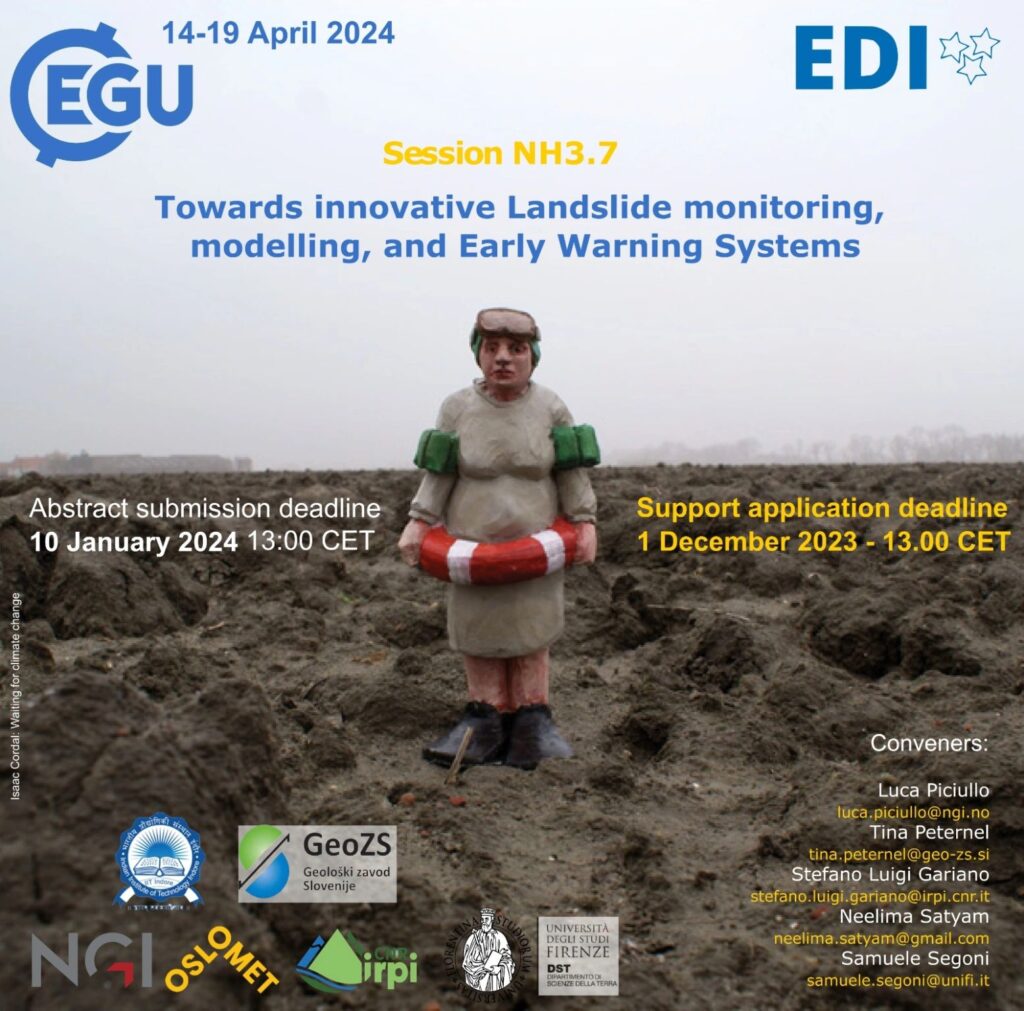
The call-for-abstracts of EGU General Assembly 2024 is open! #EGU24 will be held in Vienna, Austria, and online on 14-19 April 2024. Don’t miss the chance to submit an abstract to our session entitled Towards innovative Landslide monitoring, modelling, and Early Warning Systems!
Contributions addressing the following topics are welcome: – conventional and innovative slope-scale monitoring systems for early warning purposes – conventional and innovative regional prediction tools for warning purposes – innovative on-site instruments and/or remote sensing devices implemented in LEWS – warning models for warning/alert issuing – operational applications and performance analyses of LEWS – communication strategies – emergency phase management
The abstract submission deadline is 10 January 2024, 13:00 CET.
NEWS received from Stefano Luigi Gariano (CNR-IRPI, Italy)
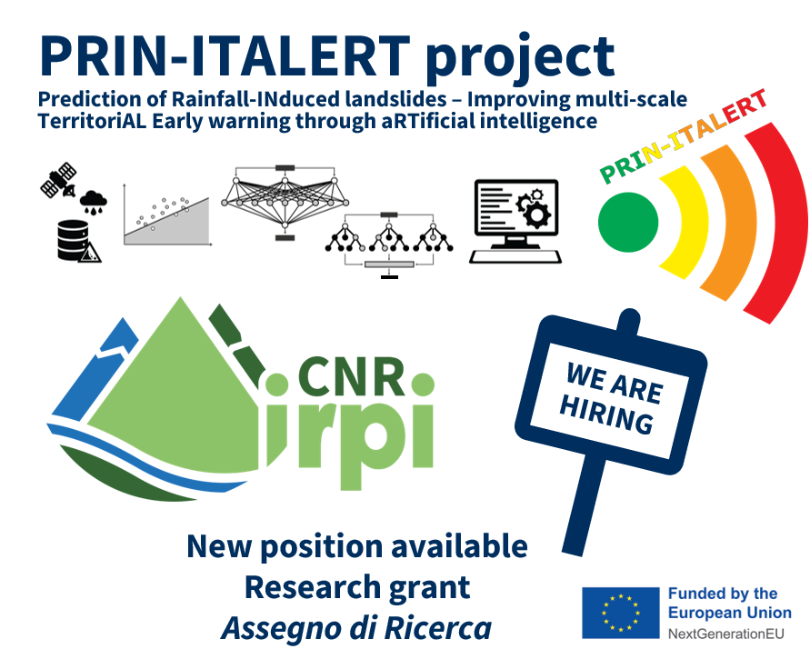
A new research grant is available at CNR-IRPI, Perugia, Italy.
The topic of the grant (on which the evaluation of qualifications and the interview will be based) is “Analysis of rainfall and geomorphological data and development of prediction models for rainfall-induced landslide triggering at a territorial scale“. The research grant is part of the project “Prediction of Rainfall-INduced landslides – Improving multi-scale TerritoriAL Early warning through aRTificial intelligence (PRIN-ITALERT)” funded by EU-NextGenerationEU.
Deadline for applications: 28 December 2023
The selection will be made by evaluation of qualifications and interview.
More information (in Italian and English) on the application and selection procedure can be found at:
The PRIN-ITALERT project (Prediction of Rainfall-INduced landslides – Improving multi-scale TerritoriAL Early warning through aRTificial intelligence) aims at improving the operational prediction of rainfall-induced landslides over large areas taking advantage of both rainfall thresholds defined using satellite-based rainfall products and innovative approaches based on artificial intelligence algorithms, in particular, Random Forest and Artificial Neural Networks. Other information about the project here: https://www.irpi.cnr.it/en/project/prin-italert/
Seminar by Simon Löw (ETH Zurich) and Andreas Huwiler (Canton of Grisons)
A seminar by Simon Löw (ETH Zurich) and Andreas Huwiler (Canton of Grisons), experts of the crisis management team, will be held online on Thursday, 18 January, 2024, 3:30 to 4:30 pm CET
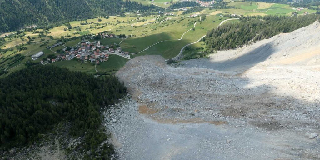
The massive landslide above Brienz/Brinzauls (Eastern Switzerland) was one of the most highly regarded events in the Alps in 2023. An entire village had to be evacuated and there was great uncertainty as to how far the released mass would run out. In this LandAware seminar, two experts from the operational crisis management will tell us how they experienced the situation before and during the event and what lessons they learned from it.
The Brienz/Brinzauls landslide. Photo by Christoph Nänni
Simon Löw (ETH Zurich) will explain the hazard scenarios, the expected and observed long-term displacement evolution, the early warning criteria and evacuation phases, and finally the collapse processes.
Andreas Huwyler (Canton of Grisons) will answer questions regarding the communication with the local people who were evacuated one month before the event and with the media.
There will also be time for questions and discussion.
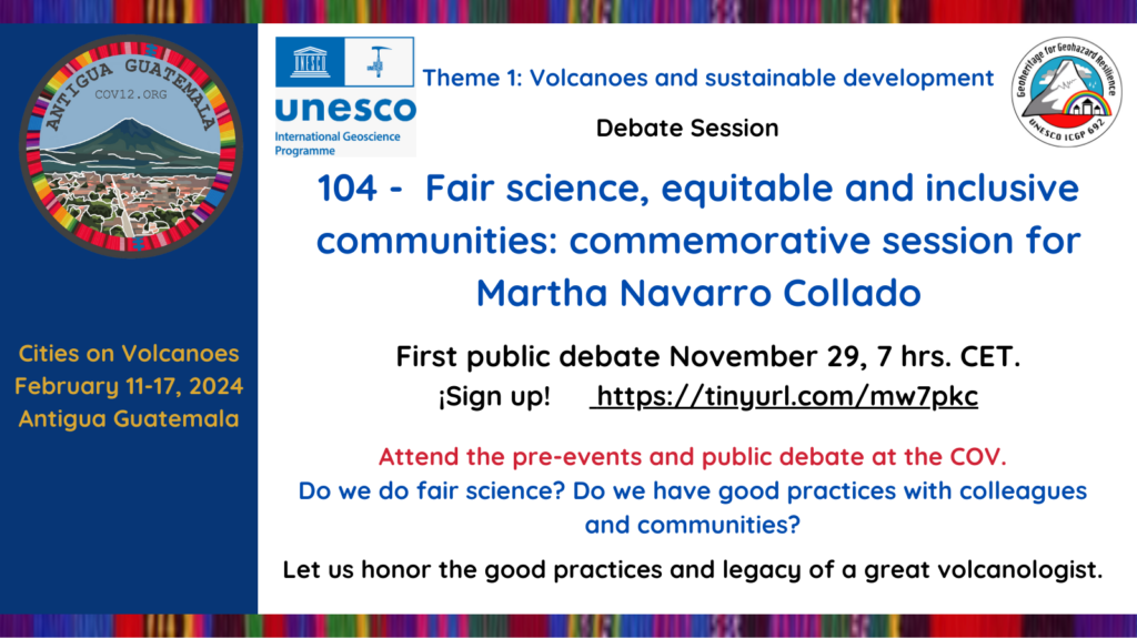
Scientists should have an obligation to make their work useful to society. To fulfill this they need to be engaged with society, including people in their science, right from the concept stages – to the final results, and to ensure that their work comes back into the communities impacted by their work.
UNESCO International Geosciences Projects 692 ‘Geoheritage for Resilience’ (www.geopoderes.com) and partners are initiating a discussion on this to cover three important aspects of scientists in society. One, the relationship between scientists from the global north and those from the global south (the latter have the money but are far removed from their impacted communities, the latter are closer but have less). Two, the relationship between local scientists and their local communities, and how to best respect the needs of both, and integrate them. Three, is it possible to draft a charter to set out the behavior that communities and southern scientists could expect northern scientists to uphold? This latter follows initiatives for ethical Science, like the Research Fairness Initiative (RFI).
These topics will be discussed in person at a session at the Cities on Volcanoes Conference, in Antigua Guatemala (11 – 17 February 2024).
Preparatory discussion will be held, starting on the 28th November 4PM CET (Spanish Language session), with an on-line discussion. Or on 29th November 7 AM CET (English Language Session).
Please join us by registering at https://tinyurl.com/yqwchyq9 (Spanish Language session) or by registering at https://tinyurl.com/mw7pkc (English Language Session) or both!
This session is a Memorial for Martha Navarro Collado, who died in 24th December 2022, and whose life’s work was an embodiment of how support at risk communities, equitable science in Nicaragua. Martha’s life is also an example of the struggle of a woman scientist from a southern (in development) country. She never hesitated to speak her mind forcibly and was very much our conscience in fair engagement across the north – south divide and between scientists and communities.
Organisors: Eveling Espinoza Jaime (Istituto Nicaragüense de Estudios Territoriales, Nicaragua), Nelida Manrique (Instituto Geológico, Minero y Metalúrgico, Peru), Mariana Patricia Jácome (Universidad Autonoma de Mexico, Mexico), Julie Morin (University of Cambridge, UK), Benjamin van Wyk de Vries (Université Clermont Auvergne, France).
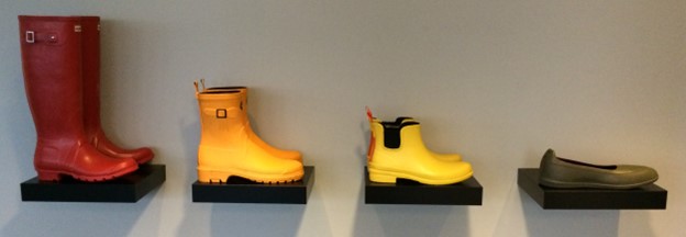
It has been 10 years since the landslide and slushflow early warning service was established in Norway. It has played an important role in increasing awareness and knowledge about landslides (i.e., debris flows, debris avalanches) and slushflows.
The iconic rubber boots that illustrate the warning levels used in Jordskredvarslingen. Photo: Hervé Colleuille, NVE
Hervé Colleuille, Heidi Grønsten, and Graziella Devoli from NVE prepared a short article to tell the story of the “Jordskredvarslingen” system, describe its strengths and provide information on the tools developed and used in the deployment of the system.
News received from Paulo Hader (PrimeIT, Brazil), Graziella Devoli (NVE, Norway)
Save the date for the Second regional meeting for Brazil (in Portuguese) organized by the WG7 Operational LEWS to establish contact among members from the same country/region, to exchange experience and to know about projects in the region and possibly to promote future collaborations among LandAware associates and observers.
Monday, 30th of October
– 18:00 (Brazilian Time, São Paulo/Rio de Janeiro)
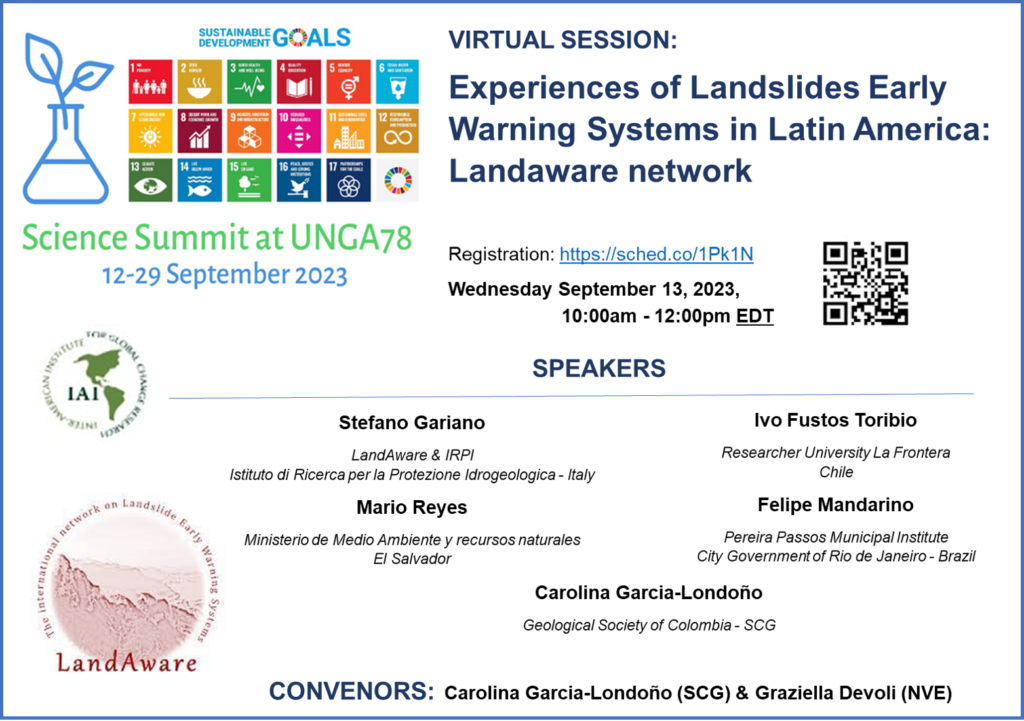
Title: Experiences of Landslides Early Warning Systems in Latin America: Landaware network / Experiencias de Sistemas de Alerta Temprana ante Deslizamientos en Latinoamérica: red Landaware
Wednesday September 13, 2023 10:00am – 12:00pmEDT (4:00pm-6pm CEST)
NEWS received from Séverine Bernardie (BRGM, France)
The IGE research unit, Grenoble, France, and BRGM (French geological survey), Orléans, France, welcome applications for a fully-funded PhD position (3 years) dedicated to the design of integrated Territorial early-warning systems for shallow landslides.
This PhD is part of the VIGIMONT project, funded by ANR (National Research Agency), and is expected to start in November 2023 (with some flexibility) ; it will be co-supervised by G. Chambon (INRAE) and S. Bernardie (BRGM) in close collaboration with S. Chave (Predict).
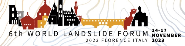
In case you will be in Florence, you need to be informed about a side event for which you may want to consider staying in Florence one more day (before or after the congress): some LandAware members from the University of Florence, together with other colleagues, will organize a guided tour on a hill in the center of Florence (3 hours walk), to let you have the best view possible of the city and to tell you some stories about how the geology of the area influenced the development of the city. That will include landslides (of course!) threatening historical buildings and remedial measures planned by Leonardo da Vinci and now forgotten by Florence people!
This activity will be scheduled on Monday (before the congress) and on Saturday (after the congress). It will be offered as a free side event and will be advertised in the near future, but considering that some of you are already booking the flights and the accommodation, it’s better to spread the word in advance.
If you are interested, just program your trip to Florence accordingly, no other action is needed from your side at this moment: you will receive an official mail from WLF6 in the next few weeks.
Of course, feel free to spread the word among other WLF6 attendees and also keep in mind that accompanying persons will be welcome (the tour is not a technical one).
Here you are the highlights of the guided tour:
• Florence 2000 years ago: Romans Vs. Etrurians in a peculiar geomorphological setting.
• Florence and its river between opportunities and disasters, searching for signs and memories that only trained eyes can see.
• The spectacular “Piazzale Michelangelo” and its incredible history, forgotten even by Florence people [spoiler: landslides involved].
• High exposure: how humanity risked living without ice cream because of a landslide (or was a landslide that gave us ice cream?).
• Palaces and churches: the story of famous ancient buildings spoken by their very stones.